50-year Water Plan for 76% more population: Ragged at same phase as Buck Mountain

Charlottesville, Va. – Since the drought of 2002, the community has chosen to build a third dam at Ragged Mountain, at the end of Fontaine Avenue on the southwest side of town, near US29 and Interstate 64.
In the beginning, there were 32 proposals, narrowed down to 4 options. Raising the South Rivanna dam 4 feet, piping water from the James River directly to your faucet, and dredging the reservoirs were possibilities. But the new dam at Ragged Mountain would raise the pool elevation 45 feet and quadruple the capacity of this dam. The older dams, 1885 and 1908, would be breached and submerged.
But the drainage basin is not big enough to fill this new reservoir. So water would be piped into it. The option of using water from the James was considered and rejected in favor of a pipeline to the South Rivanna. Buck Mountain Creek flows into the South Rivanna river and into the reservoir.
Although Buck Mountain reservoir near Free Union was never built, its waters will fill the expanded Ragged Mountain. Buck Mountain and its feeder streams will also be conserved as part of the mitigation plan on land seized 1983 by RWSA.
Is it possible the new Ragged Mountain dam will not be approved by regulators? That historical drama played out Thursday Sep. 13 at old Lane High School auditorium with about 50 people in attendance.
Executive director Tom Frederick started his presentation by saying he wants to focus on the future.
During the public comment, one speaker asked why the agency’s website had no historical information, not even things that were posted only a year ago. Does the agency need more web storage space? Or is this information routinely taken down to keep the public uninformed?
Sure enough, The 13-page contract for Rivanna to acquire 15 acres on Franklin Street at Moore's Creek for wetland mitigation, which I linked to Nov. 2, 2006, returns “file not found.”
Another person wanted to know why the website doesn’t have basic statistics available such as, how much water capacity we have. After some wrangling, that information was given.
460 -- Ragged Mountain, (MG = million gallons)
360 -- Sugar Hollow
750 – South Fork Rivanna
Total capacity = 1,570 MG or 1.57 Billion
The daily demand averaged over one year is 10.6 MGD (million gallons per day). Divide the capacity by the daily rate to find days of supply when reservoir is full. The actual supply is greater because streams flow into the reservoir.
Ragged Mountain – 43 days
Sugar Hollow – 33 days
South Rivanna – 70 days
146 days or 20 weeks of water at average demand.
Multiply this number by percent of capacity to estimate days of supply. For example, when RWSA declared a Drought Watch in July, they said reserves were 93%. (0.93)(146 days) = 135 days if no rain falls and daily demand remains the yearly average. We’re now in the mildest drought ever to trigger water restrictions.
In 2055 there will be 2,700 MG and projected 18.7 MGD of demand. 2,700/18.7=144 days of supply. If we build the new dam now and demand remains unchanged, days of supply would be closer to 254 days or 36 weeks. As demand grows, the ability to weather a severe drought decreases.
Another question raised: what future population does the plan take as an assumption? 18.7/10.6=176%, or 76% more demand. Jennifer Whitaker of RWSA staff explained there are four different methods to project population. They each have different parameters such as conservation, commercial, industrial use, water saving infrastructure, in-stream flow, sedimentation, etc. So there’s no simple answer to a simple question.
The 50-year water plan assumes 76% increase in demand, or roughly 3 more people for every 4 who live here now, other things being equal.
Others asked why there has been no dredging over the life of the Rivanna agency. One person said he reported to the authority 10 years ago that there were large tree stumps in the upstream shallow part of South Rivanna reservoir. Today that is now an island due to siltation.
Another asked why the Sugar Hollow was not cleaned out in 2002. That would have been a perfect time to dredge with bulldozers the debris Hurricane Fran washed into the reservoir Sep. 1996.
One person brought up the parkland issue, flooding the trails surrounding the present Ragged reservoir. The director has said the parkland is reservoir land and the trails will be expanded at higher elevation. This is a case where gaining parkland is represented as losing parkland to expand public land and increase tax burden on remaining landowners.
At first it seemed like the consensus was to build the complete dam and pipeline now, which would bring the greatest drought protection. But as more people spoke, it seemed cost was a greater concern. By phasing the project, future growth would pay for the infrastructure. And city residents wanted the county to pay more since most of the growth is in the county.
Don Wagner of the Albemarle County Service Authority since 1984 spoke at the end of public comment and cleared up some misconceptions. RWSA is funded by rate payers, water customers, not by taxes. Any bond to pay for the dam would be paid by water customers, including future customers. The county already pays a higher rate than the city and may pay an even higher proportion in future agreements. UVA buys water from the city, but their rates are fixed in a long-term contract.
1744 Albemarle County, county seat Scottsville
1762 Town of Charlottesville, new county seat
1865 Jefferson School
1885 First Ragged Mountain dam, real estate tax goes from 60 to 90 cents
1888 Charlottesville becomes city
1908 Second Ragged Mountain dam
1924 Sugar Hollow dam
1966 South Rivanna dam
1972 Rivanna Water and Sewer Authority created
1977 First mandatory water restrictions
1983 Buck Mountain Reservoir never built
2001 Threat of restrictions Nov. but reservoir fills without rain
2002 Second mandatory water conservation
2006 Drought Watch declared, canceled after June heavy rains
2007 Third mandatory water conservation. Third Ragged Mountain dam and mitigation plan await approval
2011 New dam safety rules
2055 Time for another dam
"Council approves Ragged Mountain option: Water for another 50 years", June 6, 2006. Includes RWSA report to Council on Feb 9, 2005. Timeline of South Rivanna reservoir.
Drought Watch: Lawn watering only at night, reservoirs full, half normal rainfall, June 19, 2006
"Drought Watch: here we go again", June 22, 2006
"Rivanna uncomfortable using Buck Mountain land for Ragged Mountain plan", November 2, 2006. The agency's signature eminent domain scandal.
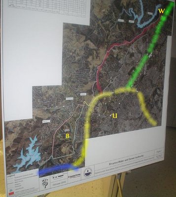
Ragged Mountain southwest, Rivanna northeast
Blue= I-64, yellow= 250 bypass, green= 29North
Red= western bypass VDOT right-of-way
B= Birdwood, W= Walmart, U= University Hall
2 possible routes for pipeline shown

Proposed Buck Mountain Reservoir, outline of RWSA-owned land, and Ragged Mountain wetland mitigation
posted by Blair at 9/18/2007 10:19:00 PM
![]()
![]()


0 Comments:
Post a Comment
<< Home