More Urban Renewal Archives Online
Charlottesville, Va.—Maybe a third of Housing Authority photographic archives are now on the internet. Only a handful of the 6,000+ text documents have been made public.
"The Vinegar Hill Project" we’ve been waiting for since 2005 is now finished. The researchers are clear that the project focuses exclusively on Vinegar Hill and other documents in the collection were disregarded. No deeds or assessments seem to be available, in contradiction to the project’s promises in Feb. 2007.
"Since 2005, researchers from the Virginia Center for Digital History and the Carter G. Woodson Institute's Center for the Study of Local Knowledge have been working with local residents, the Albemarle Charlottesville Historical Society, the Public Housing Association of Residents, the Charlottesville Redevelopment and Housing Authority, and the City of Charlottesville to digitize photographs, oral histories, and public records related to Vinegar Hill, with the aim of building an online archive and virtual tour of this urban "memoryscape." " (Source)
"Aerial Timeline" with news summaries does mention the 3 referendums in 1967, the world war two of Charlottesville’s urban renewal. (Visual Eyes)
Flickr has more photos, including the students and researchers who created the project.
Below are other archives published by Blair Hawkins. They include 152 notebook pages of photos adding up to 287 photos, copied Feb. 5, 2007. A page can have a single photo, 2, 3, or 4 photos. They also include 8 photos of 6 particular houses on Ware St. and 17 photos (10 unidentified houses and 7 aerial photos), which Hawkins photographed on separate visits in August and June 2005, respectively, when former assistant city manager Rochelle Small-Toney telephoned and presented these selected excerpts to Hawkins. Hawkins’ first request to view the archives was March 25, 2004. The archive pursuit has been documented in many publications ever since.
In Feb. 2007, the Carter G. Woodson Institute and Dr. Scot French said the archives comprise 1,189 photos, 189 maps and blue prints, and 6,845 pages of written documentation.
The archives below include Vinegar Hill pictures, but makes no effort to exclude other pieces of history, or to present Vinegar Hill as the only history we have.
You can browse the archives below. Some photos are identified because this researcher knows the detail. Others are identified from what someone else wrote on a post-it note. Many are not identified. Some notes are incorrect.If you know anything related to the photo, please leave a comment so we can piece all this history together eventually.
The photos are not limited to Vinegar Hill, or even Garrett Street urban renewal. The existence of a photo may or may not mean the agency used or threatened eminent domain. We don't have the text documents to cross-reference.
Highlights
*** The Archives are completely reproduced on BlairHawkins.net ***
UPDATE: May 8, 2017.
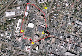
 Garrett Satellite Feb. 1, 2006
 Vinegar Hill Satellite Feb. 1, 2006
Charlottesville Redevelopment and Housing Authority photographic archives, copied June 2005 by Blair Hawkins.
Charlottesville Redevelopment and Housing Authority photographic archives, copied August 2005 by Blair Hawkins.
The first 10 pics from June 2005 and the 8 from August 2005 are also published in "An inconvenient truth: Report from Housing Authority: Update on archives, HUD request", July 17, 2006. On all 3 occasions where I had access to the archives, assistant city manager Rochelle Small-Toney presented only these hand-picked items. Later Small-Toney claimed I had been given complete access.
Below are a few newspaper articles you can read. It just seems so illiterate to have only pictures.
Daily Progress news articles.
"The Vinegar Hill Project" we’ve been waiting for since 2005 is now finished. The researchers are clear that the project focuses exclusively on Vinegar Hill and other documents in the collection were disregarded. No deeds or assessments seem to be available, in contradiction to the project’s promises in Feb. 2007.
"Since 2005, researchers from the Virginia Center for Digital History and the Carter G. Woodson Institute's Center for the Study of Local Knowledge have been working with local residents, the Albemarle Charlottesville Historical Society, the Public Housing Association of Residents, the Charlottesville Redevelopment and Housing Authority, and the City of Charlottesville to digitize photographs, oral histories, and public records related to Vinegar Hill, with the aim of building an online archive and virtual tour of this urban "memoryscape." " (Source)
"Aerial Timeline" with news summaries does mention the 3 referendums in 1967, the world war two of Charlottesville’s urban renewal. (Visual Eyes)
Flickr has more photos, including the students and researchers who created the project.
Below are other archives published by Blair Hawkins. They include 152 notebook pages of photos adding up to 287 photos, copied Feb. 5, 2007. A page can have a single photo, 2, 3, or 4 photos. They also include 8 photos of 6 particular houses on Ware St. and 17 photos (10 unidentified houses and 7 aerial photos), which Hawkins photographed on separate visits in August and June 2005, respectively, when former assistant city manager Rochelle Small-Toney telephoned and presented these selected excerpts to Hawkins. Hawkins’ first request to view the archives was March 25, 2004. The archive pursuit has been documented in many publications ever since.
In Feb. 2007, the Carter G. Woodson Institute and Dr. Scot French said the archives comprise 1,189 photos, 189 maps and blue prints, and 6,845 pages of written documentation.
The archives below include Vinegar Hill pictures, but makes no effort to exclude other pieces of history, or to present Vinegar Hill as the only history we have.
You can browse the archives below. Some photos are identified because this researcher knows the detail. Others are identified from what someone else wrote on a post-it note. Many are not identified. Some notes are incorrect.If you know anything related to the photo, please leave a comment so we can piece all this history together eventually.
The photos are not limited to Vinegar Hill, or even Garrett Street urban renewal. The existence of a photo may or may not mean the agency used or threatened eminent domain. We don't have the text documents to cross-reference.
Highlights
*** The Archives are completely reproduced on BlairHawkins.net ***
UPDATE: May 8, 2017.
 Garrett Satellite Feb. 1, 2006
 Vinegar Hill Satellite Feb. 1, 2006
Charlottesville Redevelopment and Housing Authority photographic archives, copied June 2005 by Blair Hawkins.
Charlottesville Redevelopment and Housing Authority photographic archives, copied August 2005 by Blair Hawkins.
The first 10 pics from June 2005 and the 8 from August 2005 are also published in "An inconvenient truth: Report from Housing Authority: Update on archives, HUD request", July 17, 2006. On all 3 occasions where I had access to the archives, assistant city manager Rochelle Small-Toney presented only these hand-picked items. Later Small-Toney claimed I had been given complete access.
Below are a few newspaper articles you can read. It just seems so illiterate to have only pictures.
Daily Progress news articles.
posted by Blair at 1/18/2010 12:21:00 PM
2 comments
![]()
![]()

